• Freeze Warning for Calhoun - Click for Details
    ...FREEZE WARNING NOW IN EFFECT FROM 2 AM TO 10 AM EDT WEDNESDAY...
    Effective: April 09, 2025 @ 2:00am
    Expires: April 09, 2025 @ 10:00am
    WHAT
    Sub-freezing temperatures as low as 30 expected.
    WHERE
    Portions of north central, northeast, northwest, and west central Georgia.
    WHEN
    From 2 AM to 10 AM EDT Wednesday.
    IMPACTS
    Frost and freeze conditions could kill crops, other sensitive vegetation and possibly damage unprotected outdoor plumbing.
    PRECAUTIONARY/PREPAREDNESS ACTIONS
    Take steps now to protect tender plants from the cold.
  • River Flood Warning for Calhoun - Click for Details
    ...FLOOD WARNING REMAINS IN EFFECT FROM THIS EVENING TO WEDNESDAY EVENING...
    Effective: April 08, 2025 @ 6:30pm
    Expires: April 09, 2025 @ 11:00pm
    LOCATION
    WHAT...Minor flooding is forecast.
    INFO1
    WHERE...Conasauga River at Tilton.
    INFO2
    WHEN...From this evening to Wednesday evening.
    INFO3
    IMPACTS...At 18 feet, Flood stage is reached. Minor flooding begins in the woodlands...fields and pastures along the river upstream and downstream from the gage on the Brackett Ridge Road bridge.
    INFO4
    ADDITIONAL DETAILS... - At 4:00 AM EDT Tuesday the stage was 16.3 feet. - Forecast...The river is expected to rise above flood stage this evening to a crest of 18.4 feet tomorrow morning. It will then fall below flood stage tomorrow afternoon. - Flood stage is 18 feet.
    PRECAUTIONS
    Turn around, don't drown when encountering flooded roads. Most flood deaths occur in vehicles. Motorists should not attempt to drive around barricades or drive cars through flooded areas. Additional information is available at weather.gov
  • River Flood Warning for Calhoun - Click for Details
    ...FLOOD WARNING IN EFFECT FROM EARLY THIS MORNING UNTIL FURTHER NOTICE...
    Expires: April 14, 2025 @ 9:37pm
    LOCATION
    WHAT...Minor flooding is occurring.
    INFO1
    WHERE...Oostanaula River at Calhoun.
    INFO2
    WHEN...From early this morning until further notice.
    INFO3
    IMPACTS...At 21 feet, Minor flooding begins of woodlands...fields and pastures upstream and downstream from the gage behind a water treatment plant off Mauldin Road. A boat ramp and portions of a small parking lot on the upstream and right bank side of the Georgia Highway 136 Connector will be under water.
    INFO4
    ADDITIONAL DETAILS... - At 2:30 AM EDT Tuesday the stage was 21.1 feet. - Recent Activity...The maximum river stage in the 24 hours ending at 2:30 AM EDT Tuesday was 21.1 feet. - Forecast...No forecast is available for this location. - Flood stage is 21 feet.
    PRECAUTIONS
    Turn around, don't drown when encountering flooded roads. Most flood deaths occur in vehicles. Additional information is available at weather.gov

NWS update for Sunday, April 6

SHARE NOW

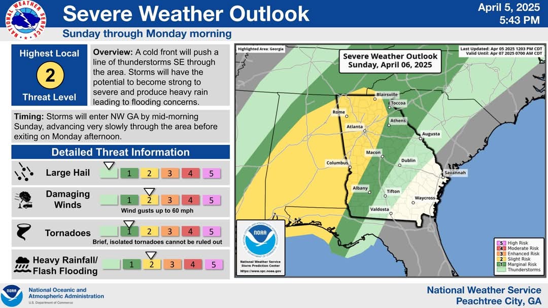
Saturday evening forecast update for Sunday 4/6:

Storms will begin to move into the area by Sunday morning and very slowly progress southeast through Sunday night.

A Slight Risk (2/5) for severe storms is in place Sunday with damaging winds being the main severe risk with a lower isolated, brief tornado threat.

The concern for heavy rainfall and flash flooding also continues to increase given slow forward movement.

A Flood Watch is in effect for much of north and west Georgia through Monday evening given forecast rainfall amounts of 2-4″ with locally higher totals expected.